
When disaster strikes, every second counts. The ability to rapidly assess damage, locate individuals in need, identify the operational status of medical facilities, and prioritize aid often means the difference between life and death. The emergency management community can turn to AI-powered geospatial analytics with real-time satellite and aerial imagery to enhance response capabilities – adding a new dimension to the way health and medical response efforts are informed.

By providing faster, more precise assessments of medical infrastructure, public health risks, and long-term recovery needs, these tools help strengthen overall emergency preparedness and response operations.
Through our current pilot initiative with WaldoAir, a member of the Civil Air Patrol (CAP), represents an effort to demonstrate and validate how AI and geospatial intelligence can help decision-makers gain greater visibility into the current state of the health infrastructure in the disaster-impacted area to speed response decisions. This work is scalable and has the potential to enhance the value of the imagery produced by the CAP and speed response efforts across the country.
The Challenge: Bridging Critical Gaps in Disaster Response
In the aftermath of a disaster, decision-makers face significant challenges in obtaining accurate, real-time data to guide their response. Key questions arise:
- Which medical facilities remain operational?
- Where are the most vulnerable populations located?
- How can resources be allocated efficiently to maximize impact?
Traditional methods rely on-the-ground reports from first responders and the community, which can be fragmented, imprecise, and reactive. Delays in response mean delays in care, increasing the risk of preventable deaths and worsening health outcomes.
Advancements in AI and geospatial analytics now provide new opportunities to enhance how we assess health risks, allocate medical resources, and support long-term recovery efforts. Our AI-driven approach provides a dynamic, real-time understanding of disaster impact zones, allowing first responders and healthcare systems to act with precision and confidence.
The Solution: GeoAI Insights Enabling Smarter Emergency Management
This challenge can be addressed through a risk analytics approach that synthesizes:
- Satellite imagery to establish a pre-disaster baseline of a region and its infrastructure with real-time aerial imagery to assess damage and medical facility status.
- Social determinants of health (SDOH) data to help identify the most vulnerable populations.
- Predictive analytics to forecast secondary health crises in disaster-affected regions.
- AI-generated insights through Anna, our generative AI Orchestrator, making complex geospatial data easily accessible through natural language queries.
This integration of AI and geospatial intelligence enables first responders, healthcare leaders, and public health officials to make smarter, faster, and more informed decisions.
How the Pilot Works: Testing AI-Powered Disaster Response
To ensure that this approach will meaningfully enhance health and medical response in disaster situations, we’ve launched a pilot to test and validate how using satellite and aerial imagery combined with our AI-powered risk assessments can provide real-time, actionable intelligence to guide decision-making in both immediate response efforts and long-term recovery operations. We aim to demonstrate how integrating these advanced capabilities can improve situational awareness, optimize resource allocation, and enhance the effectiveness of medical response teams in disaster-stricken areas.
The Key Objectives of the Pilot include:
- Determine the operational status and damage to healthcare facilities due to the disaster.
- Identify areas with high structural damage AND high health risks to prioritize response efforts.
- Forecast long-term health impacts and help public health agencies prepare for secondary crises.
By applying our AI-powered analytics to aerial imaging data produced by WaldoAir, we can map disaster-stricken areas in real-time and provide emergency teams with precise, actionable intelligence—helping them respond more effectively and save more lives.
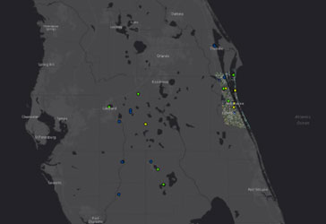
Figure 1 shows the GeoMD Platform with hospital locations identified across the State of Florida at the time of Hurricane Ian.
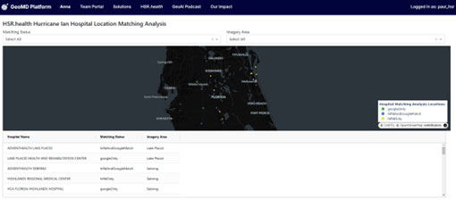
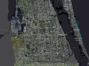
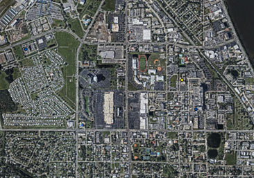
Figure 2 shows WaldoAir imagery taken during Hurricane Ian. This pilot will validate the capacity to identify storm-related damage to healthcare facilities.
If successful, this approach can be scaled beyond the pilot to support the CAP, which is comprised of several organization providing aerial surveillance and response during national disasters. With CAP’s extensive reach and fleet, integrating AI-powered health risk analytics can further enhance the speed and efficiency of disaster assessments, ensuring a faster, more coordinated response across the country.
Beyond Disaster Response: The Future of AI-Powered Risk Management
While this pilot focuses on disaster response, the implications of this GeoAI approach extend far beyond. This technology is poised to redefine emergency preparedness and healthcare resource planning in multiple ways:
- Strengthening Disaster Readiness: Governments and health systems can pre-position resources using predictive risk modeling.
- Optimizing Crisis Response: GeoAI analytics improve decision-making during disease outbreaks and pandemics, industrial accidents, and mass casualty events.
- Building Disaster Resilience: Through forecast public health risks related to hurricanes, wildfires, floods, and extreme heat events.
- Expanding Civil Air Patrol’s Impact:Health assessments add a new dimension to CAP’s aerial imagery, providing decision-makers with critical medical intelligence alongside structural and environmental data.
Performing GeoAI analysis on satellite data and ariel imagery can play a growing role in the future of emergency management – helping move from reactive to proactive disaster response.
A Smarter, Faster, More Effective Approach to Disaster Response
This effort underscores our commitment to redefining emergency preparedness through cutting-edge AI and geospatial intelligence. By merging satellite imagery as a baseline with real-time aerial data and advanced analytics, we are equipping emergency response teams with richer, more actionable information—enhancing their ability to make informed decisions and allocate resources effectively.
With our GeoMD Platform and AI-powered risk analytics, we are extract a broader scope of actionable intelligence from the collected data to help save more lives.
Please follow the progress of this pilot and stay updated as we share key findings, insights, and updates on how satellite data, ariel imagery, and GeoAI analytics can shape the future of disaster response and health risk management.