

GNSS remains central to aviation, but interference, spoofing, and environmental variability are changing how positioning and timing data are interpreted, validated, and used in modern avionics systems.

A phantom coordinate on a cockpit display used to be a rare mechanical fluke. Today, in the skies over the Persian Gulf, it’s likely a deliberate act of digital warfare.
Since the start of the U.S.-Israel war with Iran on Feb. 28, interference with location-based systems has increased across the Persian Gulf. Much of this interference is intentional, linked to efforts to disrupt drones and missiles in the region. It does not, however, remain contained and extends into civilian airspace, where aircraft operating on the same signals may begin to experience instability in navigation.
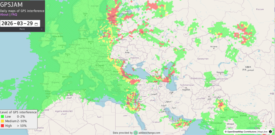
Pilots flying commercial routes through parts of the Middle East are now being warned that satellite navigation may not behave as expected.
This isn’t new or a war-time issue at all but has been building over years.
In 2023, for instance, crews over the Baltic were reporting signal instability and unexpected track deviations during routine flights. Things have become so normalized that by 2025, degraded GNSS had become something operators were expected to plan around.
The industry is finally waking up to a hard truth: satellite navigation isn’t a guaranteed right. We have moved past the era of simple signal loss and flying in a world of “digital hallucinations”, where a cockpit display can look perfectly normal while leading a plane miles off course.
GNSS as a Structural Dependency in Avionics Systems
Modern avionics architectures depend on GNSS across multiple functions. Satellite positioning and timing support flight management systems, required navigation performance procedures, ADS-B surveillance, approach guidance, and timing synchronization between onboard systems.
Beyond positioning, GNSS also supports onboard timing synchronization. Disruption or spoofing can introduce inconsistencies between navigation, surveillance, and communication systems. This dependence is not always visible in normal operations. GNSS sits behind multiple layers of avionics logic, feeding systems that appear independent but draw from the same underlying signal.
In practice, the disruption does not present the same way every time. In some cases, GNSS signals are degraded or lost. In others, they remain available but no longer reflect the aircraft’s actual position. A positioning issue can propagate across surveillance, timing, and system coordination, affecting how multiple systems interpret the aircraft’s state.
For decades, GNSS has been treated as stable and continuous. That assumption shaped how avionics systems were designed and integrated. Greater variability in those inputs changes how systems behave in practice.
Spoofing and the Question of Navigation Trust
Interference results in signal loss. Spoofing replaces the signal with a false one — the system keeps running, but on data that isn’t real.
Not all GNSS disruption is the same. Signal degradation can result from environmental conditions or limited availability. Spoofing is different. It is intentional, introduced to manipulate positioning and timing data rather than degrade it.
From an avionics perspective, that distinction matters. GNSS receivers may continue to output position and timing data that appear internally consistent but do not reflect actual aircraft state. Detection is not always immediate, and downstream systems may continue to operate on compromised inputs.
The danger is amplified by its interaction with the aircraft’s inertial systems. GNSS is used to correct drift, so prolonged spoofing can introduce erroneous corrections that crews need to identify and isolate.
Regulators have begun to reflect this shift. The ICAO has flagged GNSS interference and spoofing as a safety concern.
The FAA has warned that GPS may be unavailable, unreliable, or misleading in parts of U.S. airspace. The EASA has flagged the same issue across northern and eastern Europe, where disruption is now a recurring operational condition.
Similar disruptions have been reported across the eastern Mediterranean, parts of the Middle East, and South Asia.
What stands out is not a single incident, but the pattern. ADS-B data shows recurring anomalies across civilian aircraft — position shifts, unstable tracks, reported track that doesn’t match the aircraft’s actual flight path. These appear across regions and persist over time.
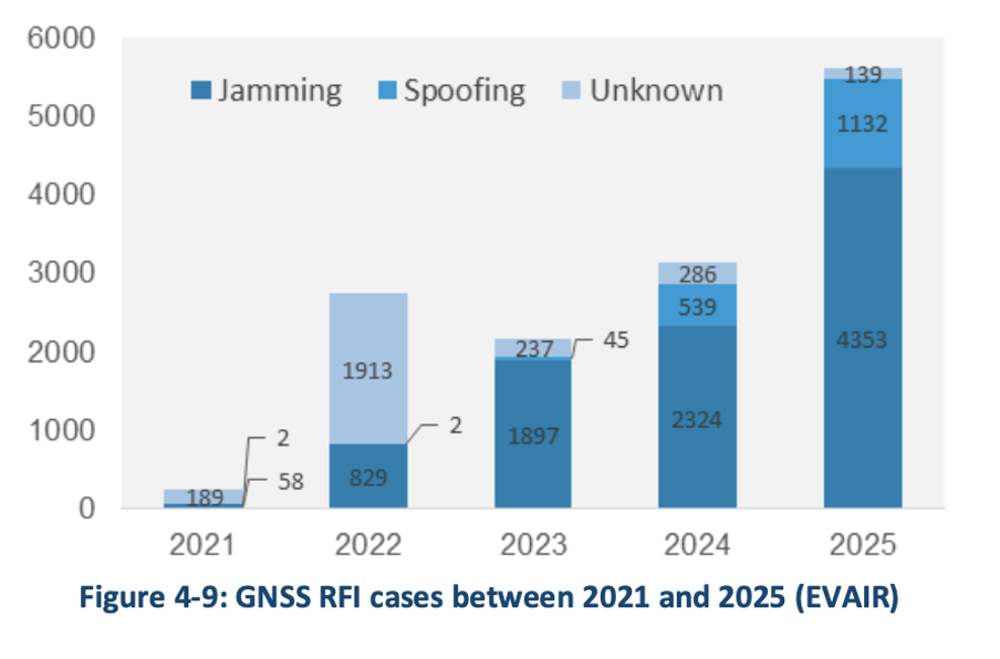
In parts of northern and eastern Europe, GNSS interference has become a recurring operational issue, with up to 38% of European en-route traffic passing through regions regularly affected by radio frequency interference, according to EUROCONTROL. In 2025, reported interference cases rose sharply, increasing by 80% as compared to 2024.
Similar conditions are now being reported across the Middle East. The problem doesn’t always show up as a failure. Signals may still be present. Systems continue to operate. The output can no longer be assumed to reflect reality.
Environmental Effects and Regional Variability
GNSS reliability is also influenced by environmental and operational conditions. GNSS doesn’t degrade the same way everywhere.
Around airports, signals bounce off buildings and surrounding terrain. At higher latitudes, satellite geometry weakens and the ionosphere becomes less stable. Airlines operating in polar and sub-polar routes have long had to account for this variability, particularly during periods of heightened solar activity.
Space weather adds another layer. Solar storms can disrupt ionospheric conditions over wide regions, degrading positioning and timing for hours at a time. These are known effects, but they introduce the same kinds of instability seen in interference — shifts in position, loss of confidence in timing, and inconsistent signal behavior.
The result isn’t a clean failure; it comes and goes. Partial loss, unstable signals, behavior that can be hard to separate from interference.
For avionics systems, this complicates alerting thresholds, redundancy strategies, and confidence assessment.
Navigation Integrity as an Avionics Requirement
Operational responses to GNSS disruption remain largely procedural. Crews revert to conventional navigation aids. Operators issue guidance. Regulators publish advisories and NOTAMs.
Design and operational emphasis is shifting toward navigation integrity – assessing whether positioning and timing information can be trusted. This is reflected in greater use of multi-constellation GNSS, tighter integration with inertial navigation systems, and more conservative system alerting.
Maintaining resilience now depends on a mix of approaches, including continued use of ground-based navigation aids, inertial systems as fallback, and greater operational awareness of interference across pilots and air traffic control.
GNSS is still central to aviation, but its output can’t be taken at face value in every condition. For avionics, the challenge is maintaining confidence in the signal as it is used.
Author
Anusuya Datta
Anusuya is a writer based in the Canadian Prairies with a keen interest in connecting technology to sustainability and social causes. Her writing explores how geospatial data, Earth Observation, and AI are reshaping the way we understand and manage our world. Disclosure: Anusuya currently works as a Content Strategist at EarthDaily. This article is written in an individual capacity, and the views expressed do not necessarily reflect those of EarthDaily or its affiliates.